I. Briefing:
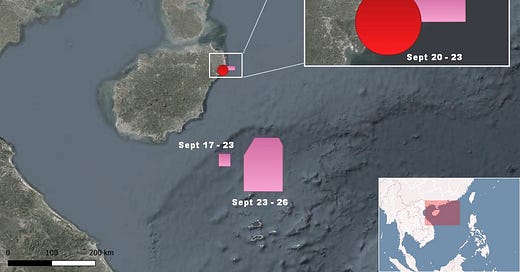
According to navigational warnings issued by Hainan Maritime Safety Agency, China will conduct several military exercises in the coming days.
Satellite image showed that China's Shandong aircraft carrier departed Sanya on September 16. It likely takes part in the exercise north of Paracel Islands.
Meanwhile, the USS Carl Vinson aircraft carrier has left the South China Sea. It was spotted operating near Okinawa on September 18.
However, USS Ronald Reagan may soon enter the South China Sea on its way back to homeport in Yokosuka after supporting the U.S. withdrawal from Afghanistan.
On September 18, China announced that several heavy military transport aircraft Y-20s had been sent to Fiery Cross Reef, Subi Reef, and Mischief Reef to bring back soldiers posted there. This is the first time China has confirmed the landing of Y-20 on airports in the Spratly Islands, although it had been spotted there earlier.
This reminds us that China has three fully operational airstrips in the Spratly Islands, and it can deploy fighter jets there at any chosen time. Is this its message?
It leads me to wonder how China react if the Biden administration allows Taiwan to change the name of its representative office. Are fighter jets at the Spratly Islands and an ADIZ in the South China Sea on the table?
II. The long read
How did Indonesia respond to China's incursion into the Natuna Sea?
There have been some developments in the Natuna Sea recently.
China deployed Coast Guard vessels to harass a drilling campaign of Indonesia in Block Tuna: China Coast Guard vessel 5202 and 5305, one after another, according to ship-tracking data.
China deployed Haiyang Dizhi 10, escorted by Coast Guard and PLA Navy, to survey Indonesia's continental shelf: CCG 4303 and Type 054A frigate Xuchang, according to my sources.
China deployed at least a Type 052D destroyer, the Kunming (172), to the Natuna Sea, according to clips recorded by Indonesian fishermen. It is likely a routine shadowing operation whenever a U.S aircraft carrier enters the South China Sea. The Xuchang frigate is not related because it came to the area earlier.
Vietnamese and China fishing vessels were seen operating in the overlapping area between Vietnam and Indonesia, according to the Indonesian Maritime Security Agency (Bakamla).
How did Indonesia respond to these developments?
It sent Bakamla's patrol vessels and the Indonesian Navy to monitor China Coast Guard vessels in the vicinity of Clyde Boudreaux drilling rig.
It sent at least an Indonesian Navy vessel (KRI Bontang, a tanker) to shadow Haiyang Dizhi 10. (It is likely a careful choice to use a tanker instead of a warship).
It deployed four more warships to the area.
Jakarta's moderate responses are understandable because any escalation could potentially lead to a conflict. But the problems are how they respond diplomatically and how they provide information to the public.
The Indonesian military only focuses on fishing vessels and a Chinese warship (the Type 052D destroyer). While there are likely some Chinese maritime militia vessels, the presence of fishing vessels is not new. It is an old problem, given that Indonesia has an overlapping EEZ with Vietnam and China's claims of traditional fishing rights in the Natuna Sea. And the presence of a Type 052D destroyer is likely a one-off. China can say that it only exercises freedom of navigation.
Indonesia military ignored two more important issues: the harassment of the drilling operation in Block Tuna and the activity of Haiyang Dizhi 10 in their continental shelf. First Fleet commander Arsyad Abdullah conducted an air patrol on September 17th and said that he saw no warships in the area. What he did not say is the presence of Haiyang Dizhi 10. How about that vessel? Why didn't he fly to the survey site and tell the public that there is a Chinese survey vessel (possibly illegal) operating in Indonesia's EEZ and continental shelf?
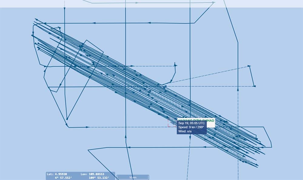
Let's take a closer look at Chinese survey vessel Haiyang Dizhi 10's operation in the Natuna Sea!
There are some early conclusions:
Its survey area is in the "overlapping zone" between Indonesia's Continental Shelf and what China dreams about the borderline of its "jurisdictional waters", aka the so-called Nine-Dash Line (The Nine-dash line was only inserted for analyzing China's intention).
The vessel sailed along an imaginary line connecting two dashes.
It focuses on the northwest/southeast axis in the survey area (about 30 lines so far). While we cannot confirm the nature of its operation, this is more like a seismic survey than scientific research.
It deliberately avoided Malaysia's continental shelf, Vietnam's continental shelf, and the Joint Defined Area between the two countries.
There are two possibilities. One is that Haiyang Dizhi 10 is conducting a seismic survey. If that is the case, it is a clear violation of Indonesia's sovereign rights.
The second is that it is running scientific research. I don't know if it is legal or not. It is in the "grey zone", and perhaps it is necessary to have permission from the host country.
However, one thing is certain: That operation is clearly designed to target Indonesia only. After all, why is scientific research bound by the borderline between countries?
We have seen this pattern of pressuring campaigns in the South China Sea before.
In May 2019, after Vietnam started a drilling campaign in Block 6.01 by Hakuryu 5, China sent Coast Guard vessels to harass. In July, it sent survey vessel Haiyang Dizhi 8 to conduct a survey in Vietnam's EEZ and continental shelf.
In late December 2019, Malaysia deployed West Capella drillship to Block ND4 and ND2, and China sent Coast Guard vessels to harass. After several months, in April 2020, it again deployed Haiyang Dizhi 8 to Malaysia's EEZ and continental shelf.
China is doing what it did to Vietnam and Malaysia. This time it targets Indonesia. At least, Indonesia can demand an explanation from China about what Haiyang Dizhi 10 is doing before considering its possible responses.
Update on the situation: CCG 4303, which has been escorting Haiyang Dizhi 10 from the beginning, left the area yesterday. According to my sources, it was replaced by CCG 5102.


About II.4, in Bakamla wrote: ""Kalau kita lihat di pantauan radar atau pantauan dari Puskodal kami, sampai saat ini di daerah overlapping itu masih ada 6 kapal-kapal Vietnam, pantauan radar, termasuk kapal-kapal coast guard China," kata Irawan. ("If we look at the radar monitoring or monitoring from our Puskodal, so far in the overlapping area there are still 6 Vietnamese ships, under radar monitoring, including Chinese coast guard ships," said Irawan). In overlapping, not in Indonesia's exclusive economic zone.